Oil & Gas Inspection
Pipeline surveillance, leak detection, facility monitoring across vast desert oil fields and offshore platforms.
Explore

Specializing in the export of industrial inspection and security drones — fully civil-compliant, desert-ready, and built for long-term partnership with distributors and enterprises across the Middle East.
From oil & gas inspection to precision agriculture, border security to infrastructure mapping — our civil-compliant UAV solutions are engineered for the demands of the Middle East's most critical sectors.
Pipeline surveillance, leak detection, facility monitoring across vast desert oil fields and offshore platforms.
Precision crop spraying, forest health monitoring, irrigation mapping, and vegetation analysis for modern farming.
Urban patrol, border monitoring, event security, and emergency response with real-time aerial reconnaissance.
Power line inspection, wind turbine monitoring, solar panel array surveys, and energy infrastructure maintenance.
Cargo delivery to remote areas, oil field supply transport, emergency supply deployment, and last-mile logistics.
Topographic mapping, 3D terrain modeling, land survey, construction site monitoring, and infrastructure planning.
Four pillars that make DronesTrading the preferred UAV export partner for Middle East distributors and enterprise buyers.
All products conform to China's Export Control Law and Middle Eastern import standards. Complete documentation, full traceability — zero customs surprises.
Rated for extreme heat, sand, and wind. Every drone in our lineup is tested for the conditions your operators face daily in the field.
24/7 remote technical assistance, full-aircraft warranty, and rapid spare parts supply. We stay with you long after the shipment lands.
Vetted domestic manufacturers, stable inventory, and fast order fulfillment — so your projects stay on schedule.
From first inquiry to successful delivery — we make the procurement process seamless and transparent.
Fill out our inquiry form or contact us via WhatsApp/Email with your requirements and target quantities.
We respond within 24 hours with a customized product proposal, pricing, and compliance documentation.
Confirm order, arrange full export documentation, and ship with complete customs clearance support.
7×24 remote technical support, warranty claims, spare parts supply, and long-term partnership follow-up.
Distributors, engineering firms, and energy enterprises across the Middle East trust DronesTrading for reliable drone supply. Start with a small trial order — no exclusivity required.

DronesTrading is a professional civil UAV export and trade service provider. Relying on a high-quality domestic supply chain, we offer compliant, reliable, and cost-effective industrial inspection, agricultural spraying, and security drone solutions for the Middle East market.
We focus exclusively on non-military civil applications: oil & gas inspection, power grid patrol, precision agriculture, infrastructure monitoring, and emergency response. Every export complies with international civil aviation standards and Middle Eastern import regulations, providing overseas partners with legal, stable, and long-term cooperation.
运营主体:GUIDEON TECH (HK) Limited
Focused exclusively on civil drone exports. No military applications involved whatsoever.
Targeting Saudi Arabia, UAE, Kuwait, Oman, Egypt and other Middle Eastern countries.
Overseas authorized distribution, small batch procurement, customized configuration services.
We deeply understand the Middle East market's compliance requirements, environmental challenges and customer needs — from product design to export procedures, from technical training to after-sales support, we provide a full-chain localized service to make your procurement worry-free and your sales hassle-free.
The S400 is GUIDEON's flagship industrial drone...
| Wheelbase | 725 mm |
| Max Takeoff Weight | 7 kg |
| Payload Capacity | 3 kg |
| Flight Endurance (No-Load) | 58–63 min |
| Max Speed | 23 m/s |
| Wind Resistance | Level 7 |
| Max Altitude | 5,000 m |
| Video Transmission | 15 km |
| Ingress Protection | IP45 |
| Navigation | GNSS + RTK + Visual Positioning |
| Obstacle Avoidance | Omnidirectional Binocular + mmWave Radar |
| Payload | 4-in-1 Smart Gimbal (Visible + IR + Laser + AI); LiDAR; Custom |
| Applications | Power Line Inspection, Security Surveillance, Geological Mapping, Environmental Monitoring, Emergency Rescue |
The S200 is a compact, foldable industrial drone...
| Folded Size | 175 × 272 × 130 mm |
| Unfolded Size | 613 × 699 × 133 mm |
| Wheelbase | 486 mm |
| Body Weight | 1,750 g |
| Max Takeoff Weight | 2,050 g |
| Flight Endurance (No-Load) | 45 min |
| Max Ascent Speed | 8 m/s |
| Wind Resistance | 12 m/s (Level 6) |
| Max Altitude | 6,000–7,000 m |
| Video Transmission | 15 km (FCC) / 8 km (CE) |
| Ingress Protection | IP43 |
| RTK Positioning Accuracy | H: ±1 cm, V: ±1.5 cm |
| AI Computing Power | 21T onboard + 100T edge |
| Obstacle Avoidance | 6-axis Binocular Vision + AI |
| Payload (Standard) | Dual-Light Gimbal (50MP + 640×512 IR); upgradable to 4-Light |
| Applications | Security Patrol, Power / Pipeline Inspection, Emergency Search & Rescue, Forestry Monitoring, Indoor Inspection |
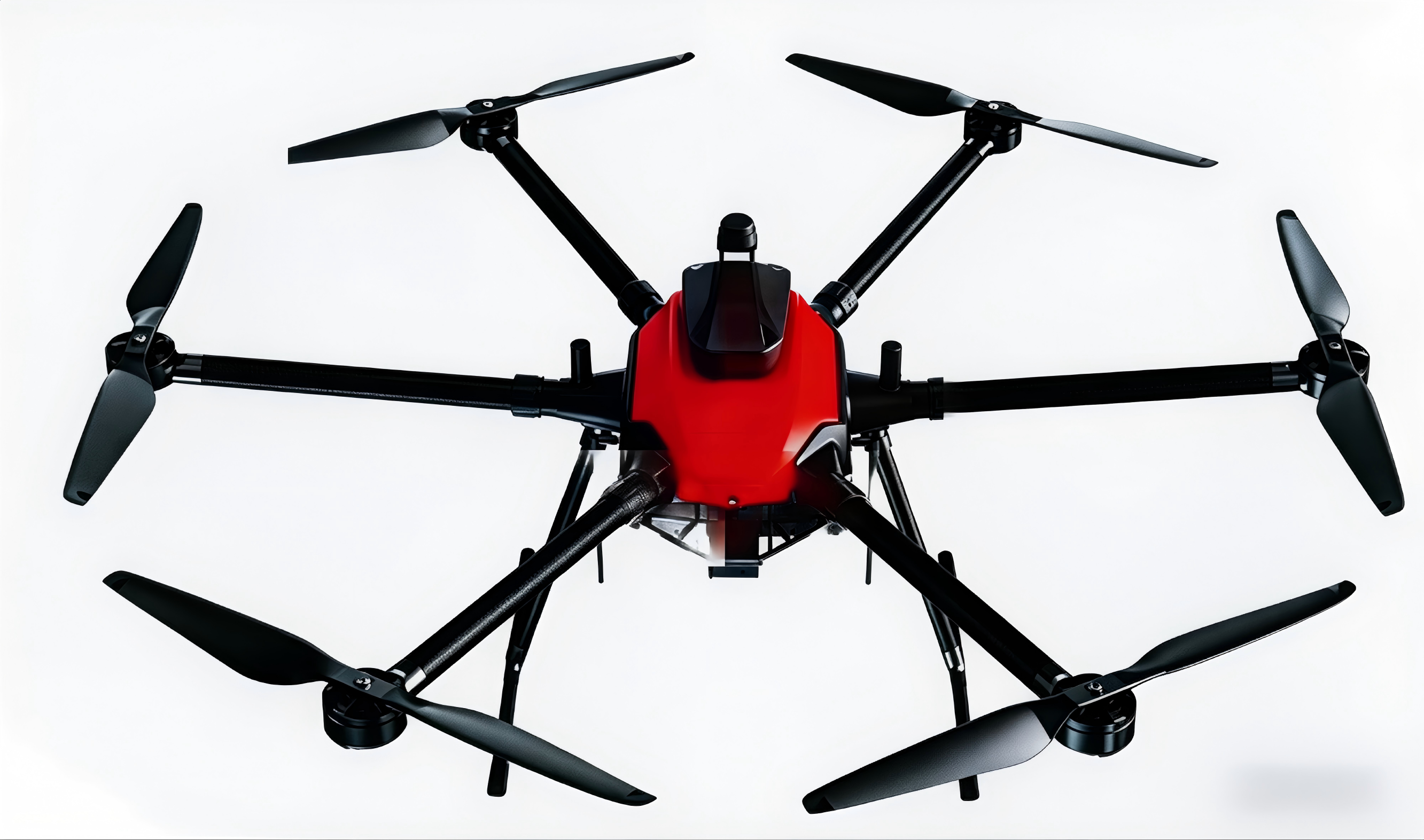
The RuYunLong is a professional heavy-lift hexacopter...
| Aircraft Type | Hexacopter |
| Wheelbase | 1,650 mm |
| Body Weight | 9.15 kg |
| Max Takeoff Weight | 28.2 kg |
| Max Payload | 10 kg |
| Flight Endurance (No-Load) | 80 min |
| Endurance (3 kg load) | 55 min |
| Endurance (10 kg load) | 36 min |
| Max Speed | 18 m/s |
| Max Altitude | 5,000 m |
| Video Transmission | 20 km (LOS) |
| Wind Resistance | Level 6 (12 m/s) |
| Operating Temperature | -20°C ~ 60°C |
| Ingress Protection | IP54 |
| Navigation | Dual RTK + GNSS, cm-level positioning |
| Battery | 22,000 mAh × 12S × 2 (dual backup) |
| Applications | Security Inspection, Fire & Rescue, Emergency Cargo Drop, Power / Pipeline Patrol, Forestry Survey, Logistics |
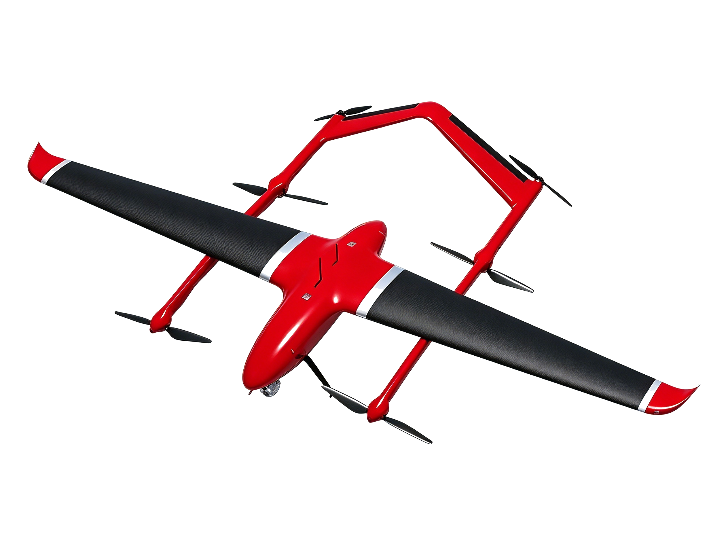
The CORBIT M11 InsertWing is an all-electric VTOL fixed-wing UAV...
| Aircraft Type | Electric VTOL Fixed-Wing, Dual-Boom |
| Airframe Material | Carbon Fiber Composite |
| Wingspan | 4,962 mm |
| Fuselage Length | 2,608 mm |
| Body Weight (excl. battery & payload) | 29.5 kg |
| Max Takeoff Weight | 50 kg |
| Max Payload | 15 kg |
| Flight Endurance (No-Load) | ≥ 240 min (4 hrs) |
| Cruise Speed | 15–20 m/s |
| Max Speed | 25 m/s |
| Max Altitude | 6,000 m |
| Wind Resistance | Level 7 |
| Operating Temperature | -20°C ~ 50°C |
| Ingress Protection | IP54 |
| Video / Data Link | 80 km HD digital |
| Navigation | GPS / BeiDou / GLONASS + RTK, cm-level |
| Obstacle Avoidance | Optional mmWave Radar + Visual |
| Deployment | Tool-free assembly, 1 person, 3 min |
| Applications | Long-Range Pipeline Inspection, Power Line Survey, Border Patrol, Emergency Cargo Transport, Communications Relay, Forest Fire Monitoring |
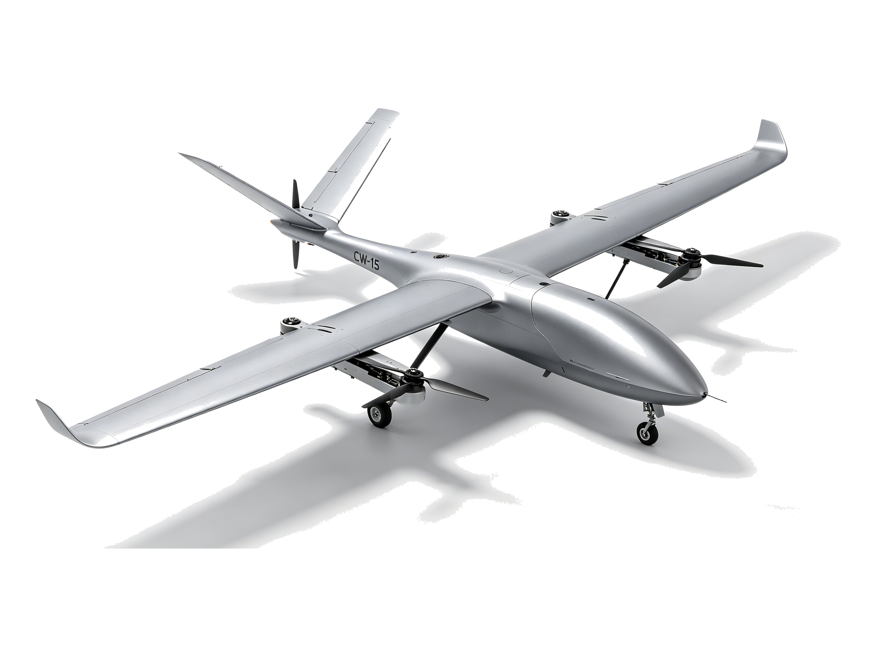
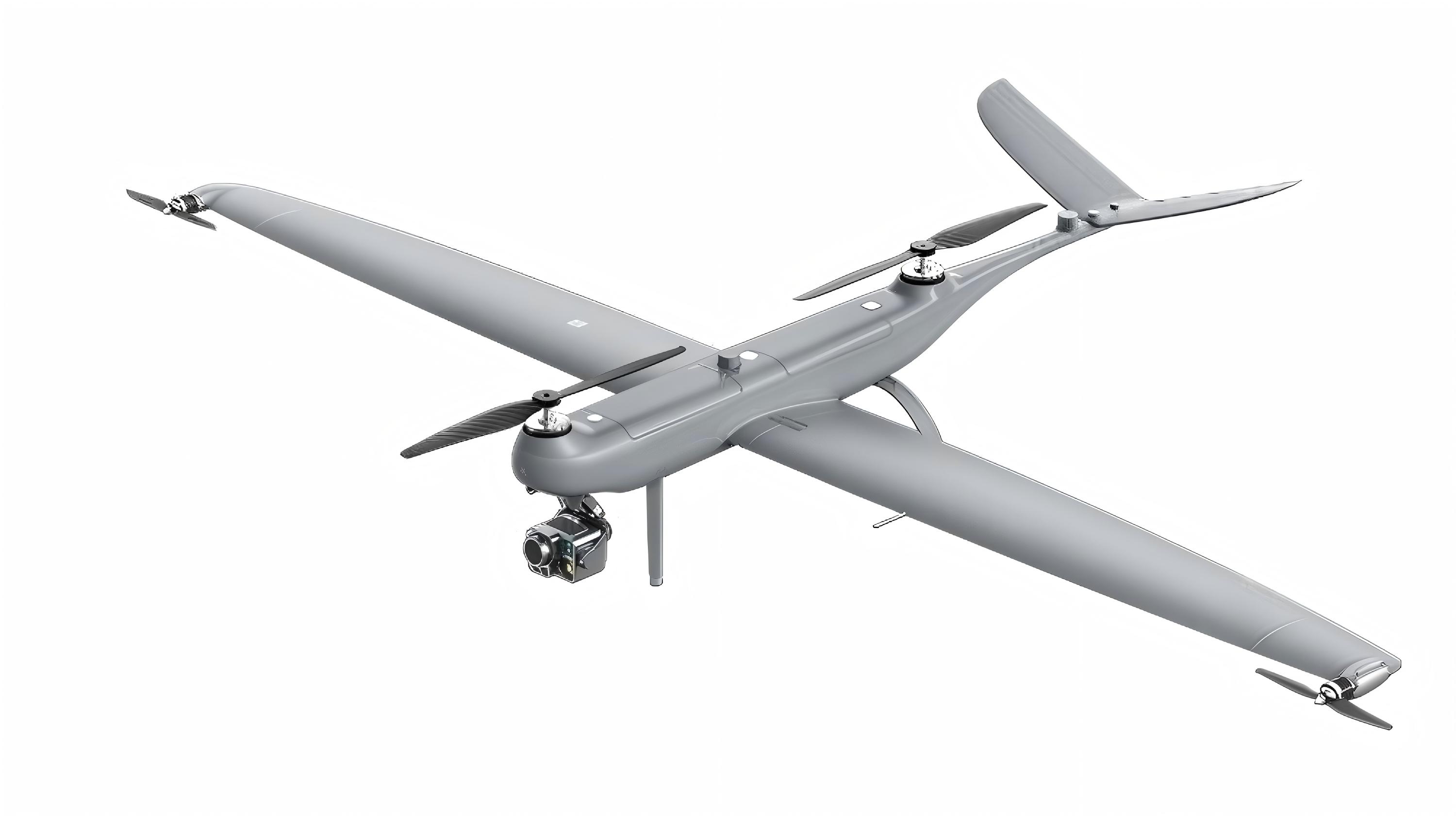
The JOUAV CW-15 is a long-endurance electric VTOL fixed-wing drone...
| Aircraft Type | Electric VTOL Fixed-Wing |
| Wingspan | 3,540 mm |
| Fuselage Length | 2,060 mm |
| Max Takeoff Weight | 17 kg |
| Empty Weight | ~12 kg |
| Max Payload | 3 kg |
| Flight Endurance (No-Load) | 120–180 min (3 hrs) |
| Cruise Speed | 61 km/h |
| Max Speed | 90 km/h |
| Max Altitude | 6,500 m |
| Max Takeoff Altitude | 4,500 m |
| Wind Resistance | Level 6 (12 m/s) |
| Operating Temperature | -20°C ~ 50°C |
| Ingress Protection | IP43 |
| Video / Data Link | 35–50 km (LOS) |
| Navigation | GPS / BeiDou / GLONASS + RTK, cm-level |
| IMU Redundancy | Triple-redundant IMU + dual GNSS |
| Obstacle Avoidance | Front + Down mmWave Radar (240 m) + Binocular Vision |
| ADS-B | 160 km air traffic awareness |
| Payload Interface | Standard quick-release, hot-swap |
| Deployment | 1 person, 15 min |
| Applications | Topographic Mapping (DOM/DEM/DSM), Power / Oil Pipeline Long-Range Inspection, Forestry & Agriculture Monitoring, Emergency Rescue, Border Patrol, Land Survey |

The XC-25 is an electric VTOL fixed-wing drone designed for long-endurance agricultural and industrial missions...
| Model | Aosu XC-25 (Dragon Duo) |
| Type | VTOL Fixed-Wing |
| Max Takeoff Weight | 25 kg |
| Max Payload | 1–6 kg |
| Empty Weight | ~19 kg |
| Max Endurance | 6 hours |
| Cruise Speed | 72–120 km/h |
| Service Ceiling | 6,000 m |
| Max Takeoff Altitude | 4,500 m |
| Control Radius | 100 km (LOS) |
| Wind Resistance | 16 m/s (Level 7) |
| Operating Temp | -20°C ~ +60°C |
| Dimensions (Deployed) | 4500 × 1631 × 657 mm |
| Ingress Protection | IP54 |
| Navigation | GPS + BDS + RTK/PPK (cm-level) |
| AI Capabilities | Auto target recognition, tracking, license plate ID |
| Applications | Aerial Mapping & GIS, Pipeline & Forestry Patrol, Security Surveillance, Emergency Rescue, Maritime Patrol |

The LV20 is a foldable octocopter purpose-built for precision agricultural spraying...
| Model | JIS LV20 |
| Structure | Octocopter (4-arm 8-rotor), Foldable |
| Wheelbase | 1,600 mm (diagonal) |
| Tank Capacity | 20 L |
| Max Payload | 20 kg |
| Max Takeoff Weight | 30 kg |
| Empty Weight | ~10 kg (excl. battery/tank) |
| Endurance (Full Load) | 18–22 min |
| Work Efficiency | 8–10 ha/day |
| Spray Width | 5–8 m |
| Flow Rate | 8 L/min (centrifugal nozzle) |
| Obstacle Avoidance | Front/rear radar + terrain-following radar + FPV |
| Ingress Protection | IP65 |
| Wind Resistance | Level 6 |
| Navigation | GPS + BDS + RTK (cm-level) |
| Folded Size | 870 × 870 × 750 mm |
| Deployed Size | 2,160 × 2,160 × 650 mm |
| Applications | Crop Spraying, Fertilizer Spreading, Seeding, Field Management |

The P150 is XAG's flagship agricultural drone, engineered for all-scenario smart farming...
| Model | XAG P150 |
| Structure | Quadcopter, Modular Quick-Swap Platform |
| Max Payload | 70 kg |
| Tank Capacity | 60 L (standard) |
| Max Spray Flow | 30 L/min |
| Max Spreading Rate | 280 kg/min |
| Ingress Protection | IP68 |
| Navigation | GPS + BDS + RTK (cm-level) |
| Propeller | 63-inch high-performance |
| Functions | Spraying, Spreading, Hauling, Aerial Surveying |
| Applications | Precision Spraying, Spreading, Hauling, Aerial Surveying |
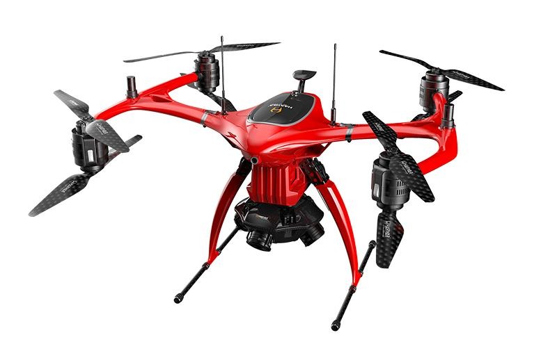
The MEGA V8 II is a professional-grade octocopter...
| Model | MEGA V8 II |
| Structure | Octocopter, Foldable |
| Dimensions | 840 × 990 × 580 mm |
| Material | T800 Carbon Fiber + Aviation Aluminum |
| Max Takeoff Weight | ~35 kg |
| Empty Weight | ~18.65 kg |
| Max Payload | 6–7 kg |
| Flight Endurance | 58–60 min |
| Max Speed | 18 m/s |
| Control / Video Link | 14.4 km |
| Max Flight Altitude | 4,384 m |
| Wind Resistance | Level 7 |
| Operating Temperature | -20°C ~ +85°C |
| Ingress Protection | IP6X |
| Navigation | GPS + GLONASS + BDS, RTK/PPK |
| Positioning Accuracy | H ≤ 1.5 cm, V ≤ 3 cm |
| Flight Controller | Dual-redundant industrial-grade |
| Applications | Security Patrol, Search & Rescue, Emergency Monitoring, Firefighting, Cargo Airdrop, Perimeter Surveillance |
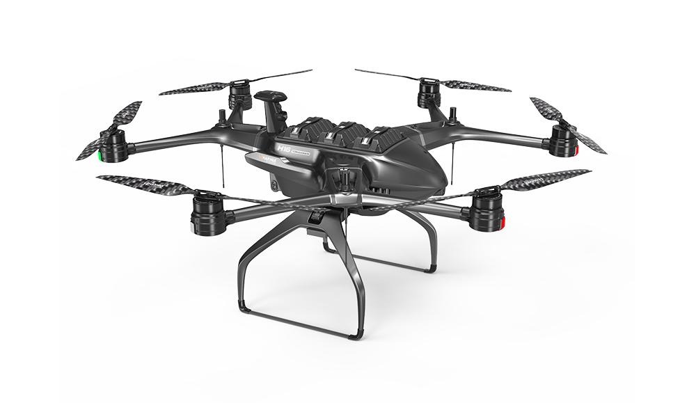
The Battle Axe H-16 is a six-axis 12-rotor heavy-lift drone...
| Model | Battle Axe H-16 V12 |
| Structure | Hexacopter (6-arm 12-rotor), Foldable |
| Dimensions | 1,530 × 1,750 × 830 mm |
| Wheelbase | 1,650 mm |
| Material | T800 Carbon Fiber + Aviation Aluminum |
| Max Takeoff Weight | ~50 kg |
| Empty Weight | ~25 kg |
| Max Payload | 25 kg |
| Flight Endurance | ≤ 60 min |
| Max Speed | 18 m/s |
| Control Range | 14.4 km |
| Max Flight Altitude | 5,834 m |
| Wind Resistance | Level 7 |
| Operating Temperature | -40°C ~ +85°C |
| Ingress Protection | IP65 |
| Navigation | GPS + BDS + GLONASS, RTK |
| Obstacle Avoidance | 720° Omnidirectional |
| Setup Time | ≤ 2 min |
| Load Points | 4 mounting points |
| Applications | Security Surveillance, Reconnaissance, Emergency Rescue, Firefighting, Crowd Control, Cargo Delivery |
The Dragonfish Pro is a tilt-rotor VTOL...
| Model | Autel Dragonfish Pro |
| Type | Tilt-Rotor VTOL |
| Dimensions (Deployed) | 1,650 × 3,040 × 460 mm |
| Empty Weight (w/ dual battery) | 14.5 kg |
| Max Takeoff Weight | 17 kg |
| Max Payload | 2.2 kg |
| Flight Endurance (Loaded) | 158 min |
| Max Speed | 108 km/h |
| Cruise Speed | 72 km/h |
| Control / Video Link | 30 / 45 km |
| Service Ceiling | 6,000 m |
| Wind Resistance (Fixed-Wing) | Level 7 |
| Wind Resistance (VTOL) | Level 6 |
| Operating Temperature | -20°C ~ +50°C |
| Ingress Protection | IP43 |
| Navigation | GPS + BDS + GLONASS, RTK |
| Positioning Accuracy | H/V ±0.1 m (RTK) |
| Obstacle Avoidance | mmWave radar + vision |
| Standard Gimbal | L20T: 4K 20x zoom + thermal |
| Deployment Time | ≤ 3 min |
| Applications | Border Patrol, Coastline Surveillance, Public Security, Forest Fire, Emergency Rescue, Pipeline Inspection |
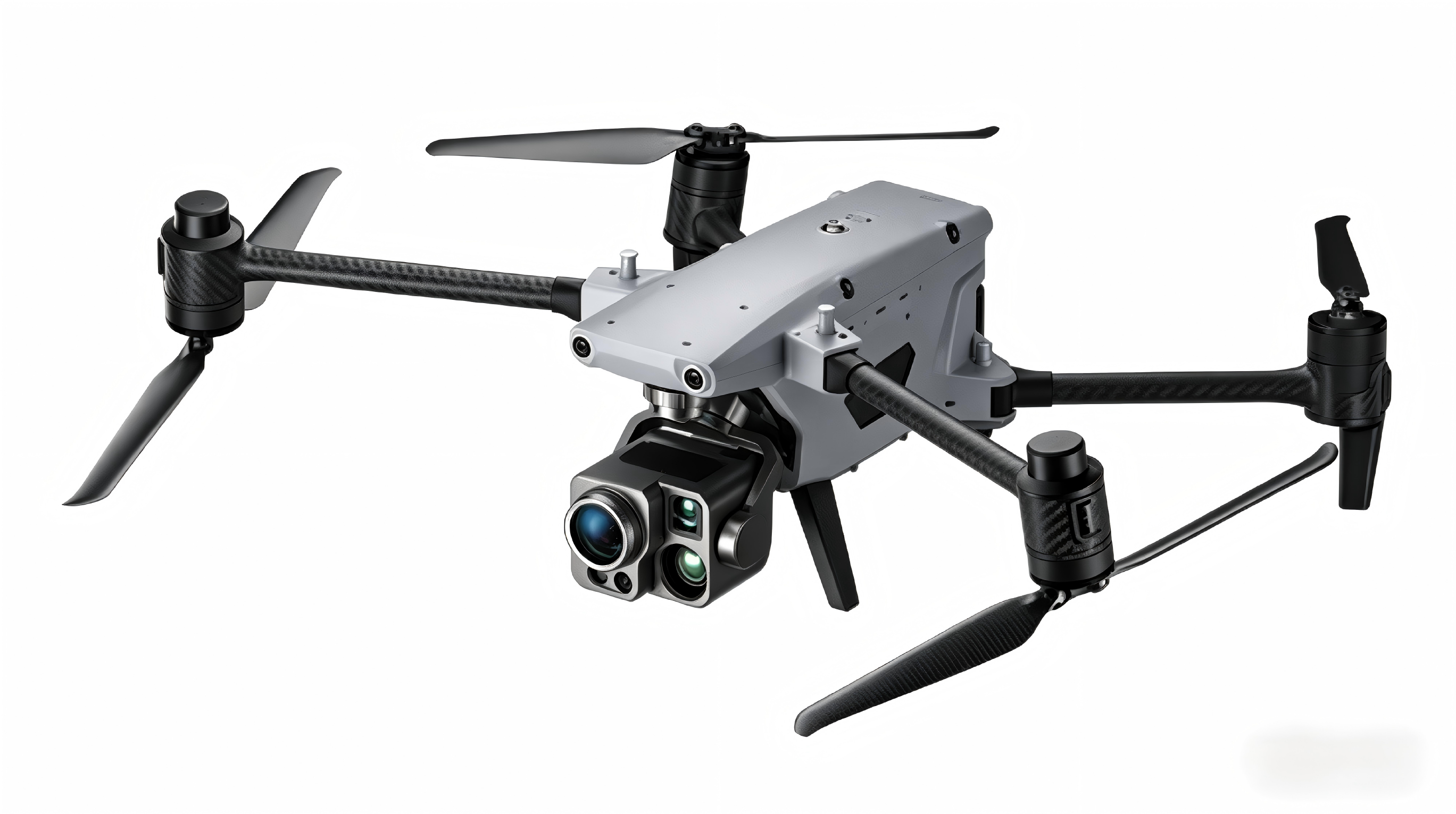
The Autel Alpha is a professional-grade multi-sensor drone...
| Model | Autel Alpha |
| Dimensions (Deployed) | 780 × 568 × 278 mm |
| Dimensions (Folded) | 455 × 263 × 248 mm |
| Wheelbase | 814 mm |
| Empty Weight | 5,535 g |
| Max Takeoff Weight | 6,480 g |
| Max Payload | 2 kg |
| Flight Endurance | 40 min |
| Battery | Dual L35T, Hot-Swap |
| Charge Time | ~60 min per battery |
| Max Speed | 23 m/s (82.8 km/h) |
| Max Ascent Speed | 15 m/s |
| Max Descent Speed | 10 m/s |
| Video / Data Link | 15 km |
| Max Takeoff Altitude | 7,000 m |
| Wind Resistance | Level 6 (12 m/s) |
| Operating Temperature | -20°C ~ +50°C |
| Ingress Protection | IP55 |
| Navigation | GPS + BDS + GLONASS + RTK |
| Positioning Accuracy | H/V ±0.1 m (RTK) |
| Obstacle Avoidance | 720° Omnidirectional + 6-direction |
| Wide-Angle Camera | 48 MP, 1/2 CMOS, 84° FOV |
| Thermal Imager | 640×512 / 13mm / 45mm |
| Laser Range Finder | 10–2,000 m |
| GNSS RTK Module | Built-in, cm-level |
| Network | 4G LTE + A-Mesh relay |
| Applications | Power Line Inspection, Pipeline Monitoring, Infrastructure Survey, Emergency Rescue, Security Patrol, Mapping |
The Yunpeng 600 is a professional heavy-lift quadcopter cargo drone...
| Model | TopFlight Yunpeng 600 |
| Airframe | Quadcopter (X), foldable Al/CF frame |
| Max Payload | 60 kg |
| Sling Mode | 50 kg (30m cable, auto-release) |
| Cargo Box Mode | 30 kg / 52 L capacity |
| MTOW | 110 kg |
| Empty Weight | ~50 kg |
| Max Speed | 20 m/s (72 km/h) |
| Cruise Speed | 35–50 km/h |
| Endurance (No-load) | 40 min (dual 20Ah) / 60 min (54Ah) |
| Endurance (Full-load) | 20 min (dual 20Ah) |
| Max Range | 20 km (electric) / 70 km (hybrid) |
| Hover Precision (RTK) | ±10 cm |
| Service Ceiling | 2,500 m |
| Wind Resistance | Level 6 (12.5 m/s) |
| Operating Temperature | -20°C ~ +50°C |
| Control Range | 30 km (dual-remote) |
| Ingress Protection | IP67 |
| Battery (Standard) | Dual 20Ah LiHV, optional 30Ah / 54Ah |
| Charging | 9 kW fast charge, ~60 min (dual batt) |
| Hybrid System | Optional range-extender hybrid |
| Deployed Span | ~2,400 mm |
| Folded Dimensions | ~1,200 × 1,200 × 800 mm |
| Safety | FPV, 4D radar, smart parachute (opt), real-time weighing |
| Cloud Platform | CargoWing fleet management & scheduling |
| Applications | Mountain & Forest Logistics, Emergency Airdrop, Construction Material Lift, Island Supply, Urban & Rural Delivery |
The EH216-L is an autonomous electric vertical take-off and landing cargo aircraft...
| Model | EHang EH216-L |
| Aircraft Type | eVTOL Autonomous Cargo Multicopter |
| Max Payload | 220 kg |
| MTOW | 600 kg |
| Cruise Speed | 100 km/h |
| Max Speed | 130 km/h |
| Range | 35 km |
| Flight Time | 21 min |
| Propellers / Motors | 16 / 16 |
| Power Source | Battery-electric |
| Charging Time | ≤ 120 min (full charge) |
| Landing Gear | Fixed skid |
| Flight Control | Fully autonomous / remote control |
| Safety Architecture | Full redundancy (DEP), Fail-Safe algorithm |
| Fleet Management | EHang centralized scheduling platform |
| Route Adaptation | Dynamic wind & payload compensation |
| Applications | Urban Express Delivery, Mountain & Remote Delivery, Cross-River Logistics, Offshore & Island Supply, Emergency Relief & Airdrop |
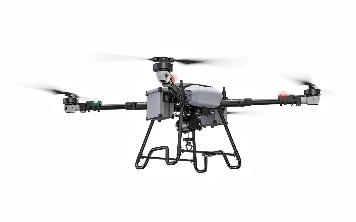
The KF200 is a professional heavy-lift quadcopter cargo drone designed for the most demanding logistics and construction tasks.
| Model | Sino-Test KF200 |
| Airframe Type | Quadcopter (X-type), foldable carbon fiber |
| Standard Payload | 180 kg |
| Max Payload | Approx. 250 kg |
| Max Takeoff Weight | 300 kg |
| Empty Weight | 115 kg |
| Task System | Intelligent sling (auto-release, one-key detaching, real-time weighing) |
| Single Motor Thrust | 85 kg (total >300 kg) |
| Propeller | 70-inch high-strength carbon fiber |
| Cruise Speed | 30–45 km/h |
| Flight Time (Dual Battery, Full Load) | Approx. 5 min |
| Flight Time (Quad Battery, Full Load) | Approx. 10 min |
| Hovering Precision (RTK) | ±10 cm |
| Wind Resistance | Level 6 |
| Control / Image Transmission Range | 2 km HD stable |
| Battery | 38 Ah smart high-voltage LiPo (grid cooling) |
| Charging | 12 kW three-phase fast charge, 220V/380V dual voltage |
| Battery Cycle Life | Approx. 1500 cycles |
| Obstacle Avoidance | 360° omnidirectional mmWave radar |
| Safety Features | Anti-swing stabilization, auto-release, warning lights, siren, optional parachute |
| Folded Dimensions | Fits standard pickup truck, 2-person portable |
| Wheelbase (Expanded) | Approx. 3.2 m |
| Applications | Infrastructure & Power Engineering, Emergency Rescue & Firefighting, Mountain & Forest Logistics, Island & Waterway Supply, Industrial & Mining Transport |
We offer multiple cooperation models designed for distributors, engineering firms, and energy enterprises. Low threshold, high flexibility, long-term win-win.
Non-exclusive authorized distribution, small batch trial orders supported. Low entry barrier with flexible terms.
Direct bulk supply for engineering and project orders. Competitive pricing with guaranteed delivery timeline.
Tailored drone configurations to meet specific project requirements. Camera, pod, payload customization available.
Neutral packaging and branding options for distributors who need their own branding on products.
Start with small trial orders to evaluate product quality. Low-risk entry for new partnerships.
Stable long-term supply chain service with full trade follow-up, ensuring timely delivery and complete documentation.
Contact us to discuss your specific requirements and find the best cooperation model for your business.
We deliver value through compliance, environmental adaptability, and reliable partnerships.
All products are fully compliant for export, meeting international aviation and customs requirements. Legal and worry-free.
High-temperature resistant, sandstorm-proof design, perfectly adapted to the harsh environments of the Middle East.
Supports multiple payloads including cameras, pods, and drop boxes. Easy to operate, low maintenance cost.
Batteries, chargers, storage cases, maintenance tools, signal boosters — everything you need, supplied quickly.
Deep understanding of local needs, regulations, and customs clearance processes in the Middle East market.
Small batch start-up supported. No exclusive pressure. Flexible and efficient cooperation for overseas engineering teams.
We work closely with leading Chinese drone manufacturers to deliver reliable, certified, and high-performance UAV solutions tailored to your market needs.

Vertical take-off fixed-wing drones for mapping, surveillance & oil/gas inspection. Industry leader in VTOL technology.
VTOL / Mapping
Professional aerial survey & remote sensing systems. High-precision mapping and photogrammetry solutions.
Survey / Remote Sensing
Industrial multi-rotor & hydrogen fuel drones. Leading power line inspection and emergency response solutions.
Industrial / Hydrogen
Enterprise & consumer drones with AI recognition. EVO series for inspection, public safety & surveying.
AI / Enterprise
Tethered drones, multi-rotor platforms & specialized payloads. Trusted for long-endurance surveillance missions.
Tethered / Payload
Global leader in agricultural drones & smart farming. Precision spraying, seeding & field monitoring systems.
Agriculture
Autonomous drone docking systems & AI-powered patrol platforms. Smart drone-in-a-box for 24/7 operations.
Automation / Docking
Industry-standard enterprise drones. Matrice & Mavic series for inspection, mapping, search & rescue.
Enterprise StandardWhether you need product information, pricing, or partnership details, we are here to help.
617A, 6/F GLOBAL PLAZA
NO.1 SHA TSUI ROAD
TSUEN WAN NT, HONG KONG
Transparency and compliance are the foundation of our business.
All drones exported by our company are for civilian use only. We strictly comply with the Export Control Law of the People's Republic of China and relevant international regulations. No products involve military use, sensitive technologies or restricted items. All products have passed official testing and certification, and can be legally exported to Middle Eastern countries.
We strictly follow China's export control laws and international trade regulations. Every export transaction undergoes thorough compliance review to ensure all products meet destination country import requirements and international standards.
We provide comprehensive customs clearance documentation assistance for Middle East imports, including product certificates, compliance declarations, and technical specifications required by local authorities.
We take data privacy seriously. Customer information collected through our website is used solely for business communication and order processing. We comply with relevant data protection regulations and do not share customer information with third parties without consent.
DronesTrading holds the necessary export permits and approvals required under the Export Control Law of the People's Republic of China. Export license numbers are provided on official export documents for each transaction. Buyers may contact us for specific license verification related to their order.
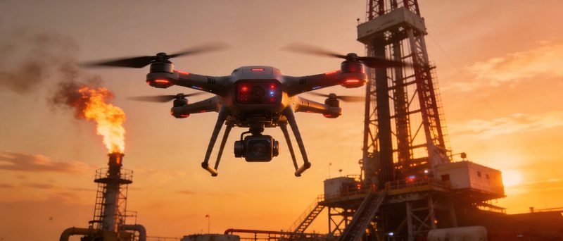
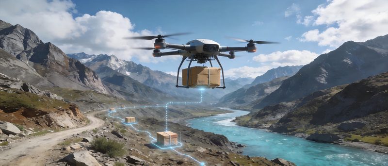
Advanced UAV solutions for pipeline surveillance, leak detection, and facility monitoring across vast desert oil fields and offshore platforms.
The oil and gas sector demands rigorous, continuous monitoring across vast and often inaccessible terrain. DronesTrading drones provide a cost-effective, safe, and efficient alternative to traditional inspection methods — enabling operators to detect anomalies early, reduce downtime, and enhance safety.
Our drones are engineered to operate reliably in extreme desert and offshore environments, tolerating high temperatures, sandstorms, and wind. Equipped with multi-spectral thermal cameras and gas detection sensors, they deliver actionable intelligence in real time.
Automated patrol of hundreds of kilometers of oil and gas pipelines. Detect cracks, corrosion, and unauthorized intrusions quickly and safely.
Infrared and gas-sensing payloads pinpoint hydrocarbon leaks at the source. Minimize environmental damage and reduce response time from days to hours.
Continuous monitoring of processing plants, compressor stations, and storage facilities. AI-assisted anomaly detection reduces the need for manned inspections.
Navigate complex offshore platform structures safely. Inspect flares, risers, and deck equipment with precision HD and thermal cameras.
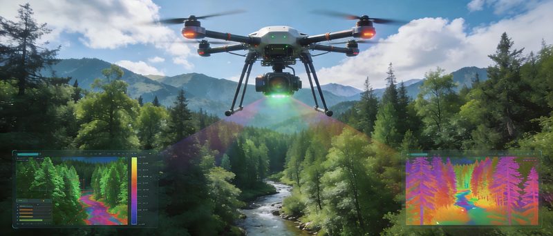
Precision crop spraying, forest health monitoring, irrigation mapping, and smart vegetation analysis for modern and desert farming.
In the arid landscapes of the Middle East, agriculture requires innovative approaches to maximize yield while conserving water and resources. Our agricultural drones bridge the gap between traditional farming and smart, data-driven cultivation.
Equipped with multi-nozzle spray systems, NDVI sensors, and high-resolution cameras, DronesTrading's agricultural UAVs help farmers monitor crop health, optimize irrigation, and reduce pesticide use through targeted precision applications.
Variable-rate spraying systems deliver pesticide, fertilizer, and growth regulators exactly where needed — reducing chemical waste by up to 40%.
Generate precise topographic and moisture maps to design efficient drip irrigation networks. Optimize water distribution in water-scarce environments.
NDVI and multispectral sensors detect early signs of disease, pests, and drought stress in forest and plantation environments.
Continuous crop growth tracking and yield prediction through aerial NDVI, NDRE, and thermal imaging data processed by AI algorithms.
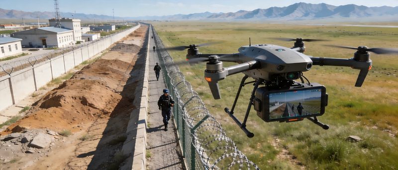
Real-time aerial intelligence for urban patrol, border monitoring, event security, and rapid emergency response.
Public safety and security organizations across the Middle East are leveraging drone technology to extend situational awareness beyond what ground patrols can achieve. DronesTrading security drones provide a cost-effective, scalable force multiplier for law enforcement, border agencies, and event organizers.
With low acoustic signature, high-resolution zoom cameras, and real-time encrypted video links, our security UAVs operate unobtrusively while delivering crisp, live footage to command centers — ensuring faster decisions and better outcomes.
Rapid aerial coverage of large urban areas. Deploy in minutes to supplement ground patrols, track suspects, and monitor crowd dynamics in real time.
Persistent surveillance of remote border segments. Long-endurance platforms with thermal night vision cover vast stretches with minimal manpower.
Aerial oversight for concerts, sporting events, and VIP gatherings. Rapid crowd management support and real-time threat identification.
First-on-scene aerial assessment for accidents, fires, and natural disasters. Deliver real-time video to incident commanders before ground teams arrive.
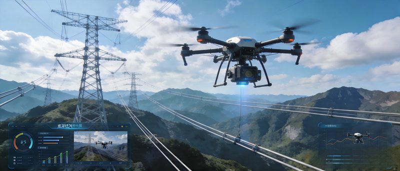
Efficient inspection of power lines, wind turbines, and solar panel arrays to maximize uptime and reduce operational costs.
Energy infrastructure inspection is a high-risk, high-cost operation. Drones dramatically reduce the need for manual line walking and climbing, improving safety while cutting inspection timelines from weeks to days.
DronesTrading power inspection drones carry high-resolution zoom cameras, LiDAR sensors, and thermal imaging — enabling detailed assessment of insulators, conductors, solar panels, and wind turbine blades in a single aerial pass.
Aerial inspection of transmission and distribution lines for broken strands, damaged insulators, and vegetation encroachment — safely and at speed.
Thermal imaging identifies hotspots, cracked cells, and soiling on solar arrays. Maximize energy output and minimize maintenance costs across large-scale installations.
High-resolution close-up inspection of turbine blades for erosion, cracks, and lightning strike damage. Reduce costly manual access and rope access operations.
Routine aerial monitoring of substations and switching equipment for signs of overheating, corrosion, and structural issues — without power outages.
Reliable cargo delivery to remote oil fields, emergency supply deployment, and last-mile logistics in challenging desert and mountain terrain.
Transporting goods to remote oil fields, offshore platforms, or mountain sites is a costly and time-consuming challenge. Cargo drones offer a transformative alternative — enabling same-day delivery of critical parts, medical supplies, and essential goods to any coordinate.
DronesTrading logistics drones are designed for heavy payloads, long distances, and harsh conditions — with autonomous flight planning, GPS-precise delivery, and safe drop-box systems that ensure goods arrive intact.
Direct delivery of tools, spare parts, and supplies to remote oil field camps and desert installations inaccessible by road.
Rapid airdrop of medical supplies, food, and relief goods to disaster zones or remote communities when road access is cut off.
Scheduled cargo runs between base camps and drilling sites, reducing ground vehicle trips and lowering the total logistics footprint.
Urban and semi-urban package delivery bypassing traffic and road infrastructure challenges — faster and more cost-effective than traditional couriers.
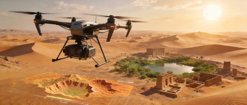
High-accuracy topographic mapping, 3D terrain modeling, and construction site monitoring for infrastructure planning and land management.
Traditional land surveying is slow, expensive, and limited in scope. Drone photogrammetry and LiDAR scanning have revolutionized the field — enabling centimeter-level accuracy over thousands of hectares in a fraction of the time.
DronesTrading mapping drones are deployed across the Middle East for large-scale desert surveys, urban planning projects, and infrastructure development. Our platforms integrate seamlessly with industry-standard GIS software to deliver production-ready outputs.
Generate detailed topographic maps, digital terrain models (DTM), and digital elevation models (DEM) with centimeter-level GSD accuracy.
Photogrammetry-based 3D point clouds and mesh models for engineering design, volumetric calculations, and stakeholder presentations.
Regular aerial surveys track progress, measure earthworks volumes, and compare as-built conditions against design plans — keeping projects on schedule.
Accurate boundary delineation and cadastral surveys for land registration, dispute resolution, and urban development planning.